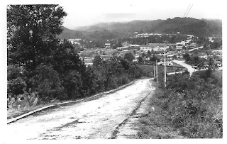
View from Bukit Salilah

I acquired this photograph off the internet the other day. When I first saw it, I immediately thought to myself, this must be the view from Bukit Salilah. That hill is about the most accessible from town and if I am not mistaken even before the second world war, there used to be built up there a telegraph tower.
Though with all the old houses and buildings at the bottom of the hill, I am not really sure whether this is taken from there. Why don't you study the photo and let me know.

Comments
I base this on looking at the sprawling Brunei General Hospital in the background, especially the 3/4 storey buildings which are the old nurses quarters beside the hospital along Jalan Sumbiling.
The width of the road is also consistent with the road leading up to the tower at the top of Bkt Selilah.
What is interesting is that the side of the road is relatively clear of vegetation. That area used to be a rubber plantation and the photograph must have been taken when the rubber trees were newly planted. I estimate the photo was taken in the late 40s.
I was trying to look for other landmarks but there were none - not even the Masjid SOAS which was complete in 1953 which should be visible.