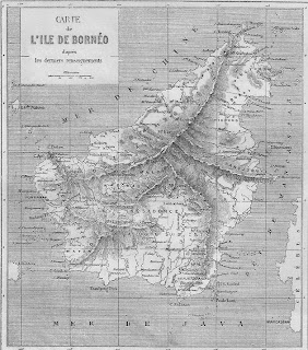
Old Borneo Map

I was spring cleaning my study yesterday and in one of the envelopes that I nearly threw away was this map of Borneo. I must have ordered this quite a while ago and have never got round to framing this. I don't know how old this map is but judging by the data should be around 100 years old at least.
The boundaries are not marked so that means Rajah Brooke have not arrived yet to take over Sarawak and Sarawak is only marked with a little dot where Kuching is today. Sabah, Sarawak and Brunei is marked 'Roy Borneo' which I take to mean 'Proper Borneo' as most other Anglicised map would show for this period. Proper Borneo is to distinguish it from the Island of Borneo and Brunei was referred to as Proper Borneo in those days.
Borneo is also marked where Bandar Seri Begawan is today with an italic lettering of Bruni to denote its other name, as far as the map is concerned.
What I like most about this map is that the Limbang River is marked as Borneo River. In those days, districts are marked by rivers. Hence, you have the Tutong District as areas of the Tutong River, Belait District as areas of the Belait River etc. The actual Brunei River is far too short to be a river for the purpose of districting and that was why the Limbang River was a better indicator of the Brunei District. Unfortunately because of catography, we named the Limbang River as the Limbang River even though hundreds of years ago, Limbang was the food basket of Brunei. So marking the Limbang River as the Borneo River in this map is correct in that sense.

Comments
and i love maps.
-KB Guy